CHeyenne river reservation
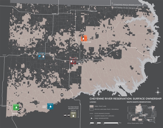
This Surface Ownership map highlights two critical issues. First, it indicates the extraordinarily complicated legal system that tribal members must navigate to own, lease or keep land in trust. Second, the map shows how land control is problematized by the fact that over 50% of the Cheyenne River Reservation has been sold off to private (non-Indian)[1] interests. This checkerboard of tribal ownership is primarily due to the 1887 Dawes Act, in which the US government allotted communal tribal land to individual tribal members, and then sold the ‘excess’ for private ownership to homesteaders.[2] This erosion of control over their land has greatly hindered the tribe’s ability to create sustainable economic activity and access resources necessary for survival and growth. Today, the majority of land along major roads—the land most suited for commerce and most fertile for agriculture and ranching—is not in trust to the tribe.
[1] We use the word Indian, rather than terms such as Native American or Native, as most people we met identified themselves as Indian. Furthermore, many political movements, tribal organizations, government agencies and laws use the term Indian; examples include the American Indian Movement, American Indian Congress, Indian Land Tenure Foundation, Indian Reorganization Act and Bureau of Indian Affairs.
[2] After 25 years, the tribal allotted land would be automatically converted into private/deeded land and subject to US taxes. The result was widespread foreclosure on Indian land, until the law was found to unfair and repealed in 1934.


